geography
Both Godly Play and Catechesis of the Good Shepherd take geography seriously.
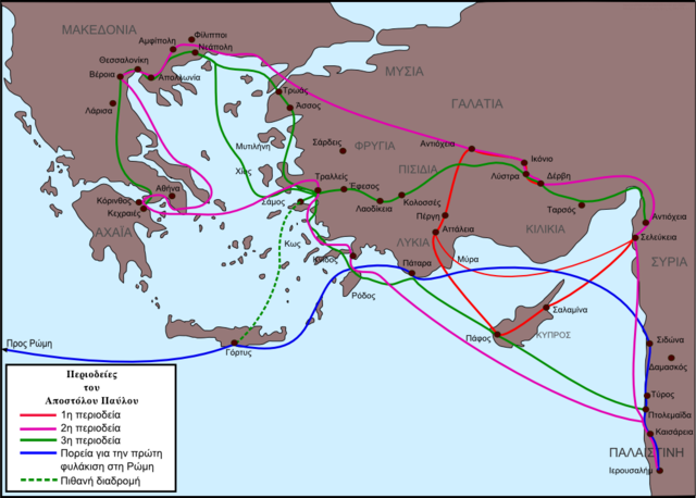
I don't remember any Biblical geography in my childhood, except maps at the back of Bibles. The ones in my Bible weren't in Greek, like the one pictured above, but they might as well have been. I looked at them sometimes if I got bored during church. I guess I thought that one day I would "learn" them, whatever that might mean. Maybe really mature Christians memorize the routes of Paul's missionary journeys?
Godly Play teaches storytellers to tell the story of Abraham's journey from Ur to the oaks of Mamre with relative geographical accuracy, and the same for the story of the Babylonian captivity. It's not made into a big deal. Children aren't asked to "learn" it; they're simply shown. The storyteller lays blue ribbons onto the sand - Here is the Tigris river, here is the Euphrates. The message is, This is what I need to get ready in order to tell this story.
(The storyteller does this all "upside-down" so that North is at the top for children sitting opposite.) The rivers serve as points of orientation, I suppose, and when the child later sees a map like this they can think, Oh yes, I'm familiar with that place.
 |
| map by Geraki |
I don't remember any Biblical geography in my childhood, except maps at the back of Bibles. The ones in my Bible weren't in Greek, like the one pictured above, but they might as well have been. I looked at them sometimes if I got bored during church. I guess I thought that one day I would "learn" them, whatever that might mean. Maybe really mature Christians memorize the routes of Paul's missionary journeys?
Godly Play teaches storytellers to tell the story of Abraham's journey from Ur to the oaks of Mamre with relative geographical accuracy, and the same for the story of the Babylonian captivity. It's not made into a big deal. Children aren't asked to "learn" it; they're simply shown. The storyteller lays blue ribbons onto the sand - Here is the Tigris river, here is the Euphrates. The message is, This is what I need to get ready in order to tell this story.
 |
| public domain map by Kostisl |
In Catechesis of the Good Shepherd, the materials for 3-year-olds include a small globe. It is simple, showing only land and water. Ideally, the land is slightly textured, encouraging the child to run their fingers across it. The only marking is a small dot, showing where the land of Israel is. The catechist explains that when Jesus was born, he came to a very tiny place. That idea is left to grow in the child's mind, the beginning of a recurring theme of paradox -
Humility / Immensity (All things were made by him).
Later, perhaps some weeks or months later, the child is introduced to a topographical map of that land of Israel.
The map is 3D. Most of the land is built up higher than the sea but the shores of the Dead Sea are below sea level. The child is encouraged to spend time feeling the mountains and valleys, the river and the sea. This is the land where Jesus was born, and where he grew up, where he died and then came to life again. Later still, the child will be shown where the cities of Bethlehem, Nazareth, and Jerusalem are. It's all a very hands-on experience, putting across the message that Jesus came into human history in a concrete place.
Humility / Immensity (All things were made by him).
Later, perhaps some weeks or months later, the child is introduced to a topographical map of that land of Israel.
 |
| licensed map image |


Comments
Post a Comment